Fail:1794 Anville Map of Ancient Egypt - Geographicus - Egypt-anville-1794.jpg

Saiz pralihat ini: 400 × 600 piksel. Leraian-leraian lain: 160 × 240 piksel | 320 × 480 piksel | 512 × 768 piksel | 683 × 1,024 piksel | 1,366 × 2,048 piksel | 2,668 × 4,000 piksel.
Fail asli (2,668 × 4,000 piksel, saiz fail: 2.64 MB, jenis MIME: image/jpeg)
| Jean Baptiste Bourguignon d'Anville: Aegyptus Antiqua Mandato Serenissimi Delphini Publici Juris Facta.
( |
|||||||||||||||||||||
|---|---|---|---|---|---|---|---|---|---|---|---|---|---|---|---|---|---|---|---|---|---|
| Seniman |
|
||||||||||||||||||||
| Tajuk |
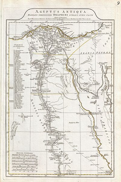
Aegyptus Antiqua Mandato Serenissimi Delphini Publici Juris Facta. |
||||||||||||||||||||
| Keterangan |
English: A large and dramatic 1794 J. B. B. D'Anville map of Ancient Egypt Covers from the Nile Delta and Gaza south as far as Aswan. Details mountains, rivers, cities, roadways, and lakes with political divisions highlighted in outline color. Features both ancient and contemporary place names, ie. Thebae and Luxor, for each destination - an invaluable resource or scholars of antiquity. Identifies the Pyramids, Mount Sinai, Natron, Philae Island, the Cataracts, etc. Title area appears in a raised zone above the map proper. Includes six distance scales, bottom left, referencing various measurement systems common in antiquity. Text in Latin and English. Drawn by J. B. B. D'Anville in 1762 and published in 1794 by Laurie and Whittle, London. |
||||||||||||||||||||
| Tarikh | 1794 (dated) | ||||||||||||||||||||
| Matra | tinggi: 20 in (50.8 cm); lebar: 12.5 in (31.7 cm) | ||||||||||||||||||||
| Nombor induk |
Geographicus link: Egypt-anville-1794 |
||||||||||||||||||||
| Sumber/Jurugambar |
D'Anville, J. B. B., Complete Body of Ancient Geography, Laurie and Whittle, London, 1795.
|
||||||||||||||||||||
| Kebenaran (Penggunaan semula fail ini) |
|
||||||||||||||||||||

Sejarah fail
Klik pada tarikh/waktu untuk melihat rupa fail tersebut pada waktu itu.
| Tarikh/Waktu | Gambar kenit | Ukuran | Pengguna | Komen | |
|---|---|---|---|---|---|
| semasa | 14:49, 23 Mac 2011 | | 2,668 × 4,000 (2.64 MB) | BotMultichillT | {{subst:User:Multichill/Geographicus |link=http://www.geographicus.com/P/AntiqueMap/Egypt-anville-1794 |product_name=1794 Anville Map of Ancient Egypt |map_title=Aegyptus Antiqua Mandato Serenissimi Delphini Publici Juris Facta. |description=A large and d |
Penggunaan fail
Laman berikut menggunakan fail ini:
Penggunaan fail sejagat
Fail ini digunakan oleh wiki-wiki lain yang berikut:
- Penggunaan di bn.wikipedia.org
- Penggunaan di en.wikipedia.org
- Penggunaan di id.wikipedia.org
- Penggunaan di io.wikipedia.org
- Penggunaan di ru.wikipedia.org
- Penggunaan di sk.wikipedia.org
- Penggunaan di ta.wikipedia.org
- Penggunaan di xmf.wikipedia.org