Fail:2011 Tohoku earthquake observed tsunami heights en.png
Saiz pralihat ini: 656 × 600 piksel. Leraian-leraian lain: 263 × 240 piksel | 525 × 480 piksel | 700 × 640 piksel.
Fail asli (700 × 640 piksel, saiz fail: 298 KB, jenis MIME: image/png)
| Keterangan |
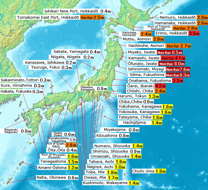
English: Map of 2011 Tohoku(Sendai) earthquake observed tsunami heights in Japan.
日本語: 東北地方太平洋沖地震で観測された、日本各地の津波の高さ(英語版)。 |
||||||
| Tarikh | |||||||
| Sumber |
This file was derived from: 2011 Tohoku earthquake observed tsunami heights.png |
||||||
| Pengarang | Original by Pekachu, translated by Eastwind41 | ||||||
| Kebenaran (Penggunaan semula fail ini) |
|
||||||
| Versi lain |
SVG re-designed version available |
| Ini adalah gambar sentuh, ini bermakna bahawa ia telah didigitalkan dari versi asal. Modifikasi: Place name translating to English language(地名の英訳).
|
Sejarah fail
Klik pada tarikh/waktu untuk melihat rupa fail tersebut pada waktu itu.
| Tarikh/Waktu | Gambar kenit | Ukuran | Pengguna | Komen | |
|---|---|---|---|---|---|
| semasa | 13:43, 14 Mei 2011 | | 700 × 640 (298 KB) | Eastwind41 | {{Information |Description ={{en|1=Map of 2011 Tohoku(Sendai) earthquake observed tsunami heights in Japan.}} {{ja|1=東北地方太平洋沖地震で観測された、日本各地の津波の高さ(英語版)。}} |Source ={{Derived from|2011 |
Penggunaan fail
Laman berikut menggunakan fail ini:
Penggunaan fail sejagat
Fail ini digunakan oleh wiki-wiki lain yang berikut:
- Penggunaan di en.wikipedia.org
- Penggunaan di mk.wikipedia.org
- Penggunaan di ro.wikinews.org
- Penggunaan di th.wikipedia.org