Fail:Chancellorsville May3a.png
Saiz pralihat ini: 800 × 533 piksel. Leraian-leraian lain: 320 × 213 piksel | 640 × 427 piksel | 1,024 × 683 piksel | 1,280 × 854 piksel | 2,560 × 1,707 piksel | 6,300 × 4,201 piksel.
Fail asli (6,300 × 4,201 piksel, saiz fail: 8.59 MB, jenis MIME: image/png)
| Keterangan |
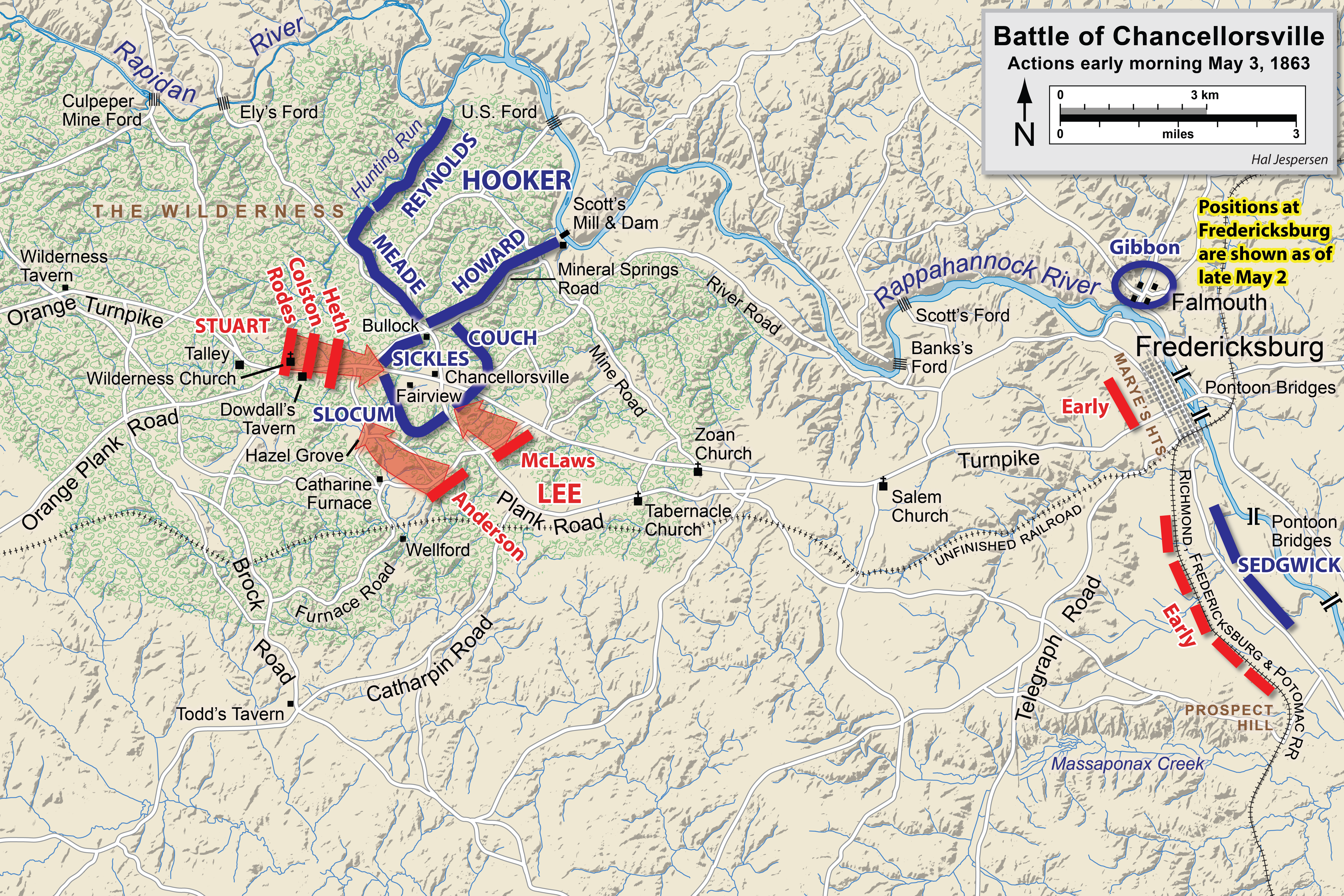
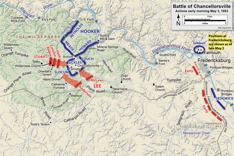
English: Map of a portion (May 3, early morning) of the battle of Chancellorsville of the American Civil War. This map partially replaces the map entitled Chancellorsville May3.png.
Drawn in Adobe Illustrator CS6 by Hal Jespersen. Graphic source file is available at http://www.cwmaps.com Fail ini dilesenkan di bawah lesen Pengiktirafan 3.0 Tidak Diport Creative Commons. Pengiktirafan: Map by Hal Jespersen, www.cwmaps.com
|
| Tarikh | |
| Sumber | Karya sendiri |
| Pengarang | Hlj |
Sejarah fail
Klik pada tarikh/waktu untuk melihat rupa fail tersebut pada waktu itu.
| Tarikh/Waktu | Gambar kenit | Ukuran | Pengguna | Komen | |
|---|---|---|---|---|---|
| semasa | 18:14, 14 Mac 2023 | | 6,300 × 4,201 (8.59 MB) | Hlj | improved graphics |
| 17:52, 30 Disember 2012 |  | 2,500 × 1,822 (1.39 MB) | Hlj | Corrected spelling error, made minor graphic improvements | |
| 22:16, 3 Jun 2011 |  | 2,500 × 1,822 (1.33 MB) | Hlj | Improved the accuracy of the terrain and some landmarks. Same license. | |
| 19:33, 27 Mac 2011 |  | 2,500 × 1,822 (1.28 MB) | Hlj | Update to graphical style of rivers and roads. Same license. | |
| 22:00, 27 Januari 2011 |  | 2,500 × 1,822 (1,013 KB) | Hlj | Minor updates to feature labeling and unit positions and actions. {{cc-by-3.0|Map by Hal Jespersen, www.posix.com/CW}} | |
| 00:15, 28 November 2010 |  | 2,500 × 1,822 (1,005 KB) | Hlj | {{Information |Description={{en|1=Map of a portion (May 3, early morning) of the battle of Chancellorsville of the American Civil War. This map partially replaces the map entitled Chancellorsville May3.png. Drawn in Adobe Illustrator CS5 by Hal Jesper |
Penggunaan fail
Laman berikut menggunakan fail ini:
Penggunaan fail sejagat
Fail ini digunakan oleh wiki-wiki lain yang berikut:
- Penggunaan di bg.wikipedia.org
- Penggunaan di en.wikipedia.org
- Penggunaan di es.wikipedia.org
- Penggunaan di fr.wikipedia.org
- Penggunaan di hu.wikipedia.org
- Penggunaan di pt.wikipedia.org
- Penggunaan di ro.wikipedia.org