Fail:Cyclone Larry 19 mar 2006 0025Z.jpg

Fail asli (5,600 × 7,200 piksel, saiz fail: 5.69 MB, jenis MIME: image/jpeg)
Ringkasan
| Keterangan |
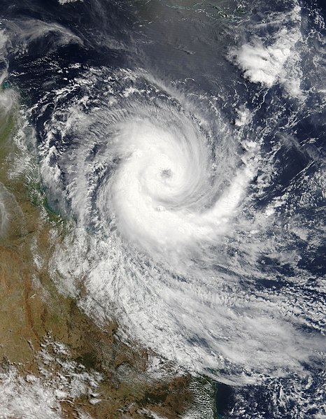
Australia on March 18, 2006, but built strength rapidly. When the Moderate Resolution Imaging Spectroradiometer (MODIS) on the Terra satellite observed the storm at 11:55 a.m. Eastern Australian Daylight Time (00:55 UTC) on March 19, 2006, only a day later, Larry had already reached considerable size and power, with peak sustained winds of 120 kilometers per hour (75 miles per hour). Within the next eighteen hours, according to the Tropical Storm information service at the University of Hawaii, sustained winds reached 185 km/hr (115 mph), just before the storm came ashore. It lost power over land. This image shows Cyclone Larry as it was bearing down on the coast of Queensland over the Great Barrier Reef. During the next day, Larry caused considerable damage to coastal towns and property, flattening sugar cane fields. According to the Australian Broadcasting Corporation, as much as 90 percent of the Australian banana crop may have been lost in this single storm. Since many trees have been destroyed, it may be many years before the banana industry recovers. The high-resolution image provided above is provided at the full MODIS spatial resolution (level of detail) of 250 meters per pixel. The MODIS Rapid Response System also provides this image at additional resolutions. |
|||||
| Tarikh | ||||||
| Sumber | http://earthobservatory.nasa.gov/NaturalHazards/natural_hazards_v2.php3?img_id=13421 | |||||
| Pengarang | NASA image by Jeff Schmaltz, MODIS Rapid Response Team, Goddard Space Flight Center. | |||||
| Kebenaran (Penggunaan semula fail ini) |
|
|||||
| Versi lain | Image:Cyclone Larry 2006.jpg |

Sejarah fail
Klik pada tarikh/waktu untuk melihat rupa fail tersebut pada waktu itu.
| Tarikh/Waktu | Gambar kenit | Ukuran | Pengguna | Komen | |
|---|---|---|---|---|---|
| semasa | 20:29, 18 November 2006 | | 5,600 × 7,200 (5.69 MB) | Good kitty | == Summary == {{Information |Description=Tropical Cyclone Larry formed off the northeastern coast of Australia on March 18, 2006, but built strength rapidly. When the Moderate Resolution Imaging Spectroradiometer (MODIS) on the Terra satellite observed th |
Penggunaan fail
Laman berikut menggunakan fail ini:
Penggunaan fail sejagat
Fail ini digunakan oleh wiki-wiki lain yang berikut:
- Penggunaan di ar.wikipedia.org
- Penggunaan di be.wikipedia.org
- Penggunaan di bn.wikipedia.org
- Penggunaan di ca.wikipedia.org
- Penggunaan di cv.wikipedia.org
- Penggunaan di de.wikipedia.org
- Penggunaan di en.wikipedia.org
- Coral Sea
- Wikipedia:Selected anniversaries/March 20
- Cyclone Larry
- Portal:Environment
- Portal:Tropical cyclones/Did you know/Archive
- Portal:Tropical cyclones/Anniversaries
- Portal:Tropical cyclones/Anniversaries/March
- Portal:Tropical cyclones/Anniversaries/March/20
- Environmental threats to the Great Barrier Reef
- Wikipedia:Main Page history/2016 March 20
- Penggunaan di es.wikipedia.org
- Penggunaan di ga.wikipedia.org
- Penggunaan di he.wikipedia.org
- Penggunaan di krc.wikipedia.org
- Penggunaan di mhr.wikipedia.org
- Penggunaan di pnb.wikipedia.org
- Penggunaan di ru.wikipedia.org
- Penggunaan di sr.wikipedia.org
- Penggunaan di uk.wikipedia.org
- Penggunaan di ur.wikipedia.org
- Penggunaan di zh.wikipedia.org