Fail:Geography of Afghanistan.jpg
Saiz pralihat ini: 800 × 539 piksel. Leraian-leraian lain: 320 × 216 piksel | 640 × 431 piksel | 1,024 × 690 piksel.
Fail asli (1,024 × 690 piksel, saiz fail: 428 KB, jenis MIME: image/jpeg)
Ringkasan
| Keterangan |
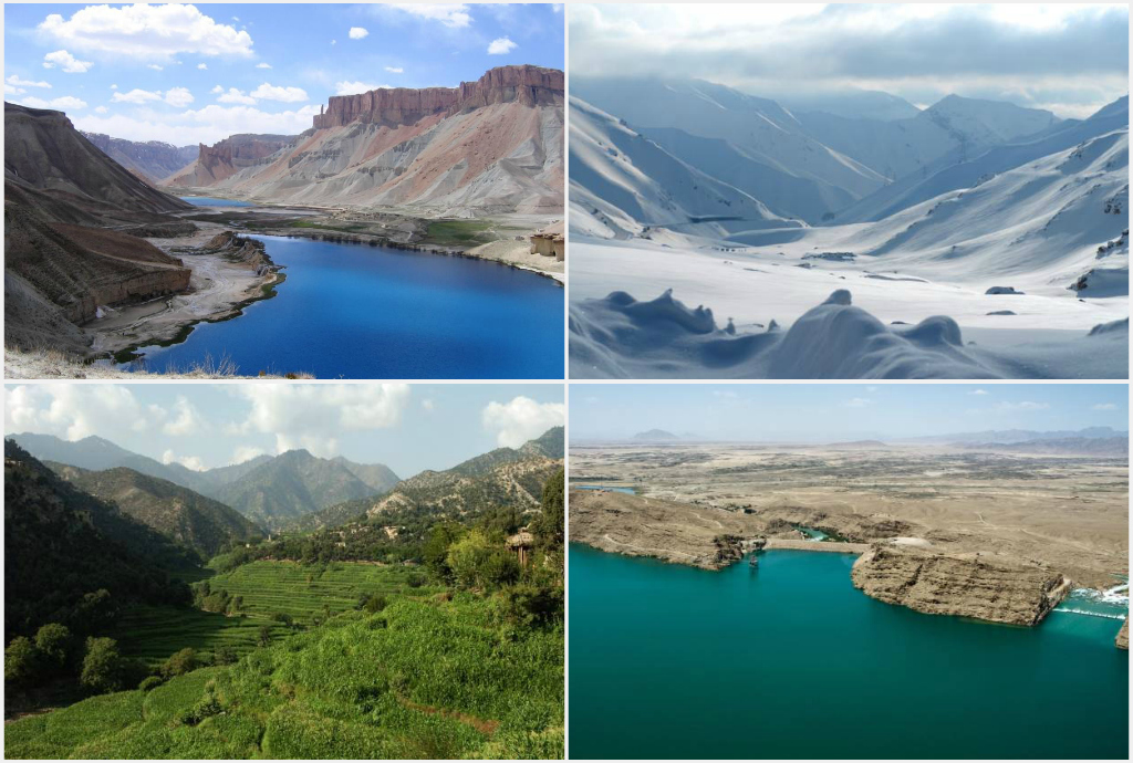
English: Afghanistan collage, from left to right: 1. Band-e Amir National Park in Bamyan province, 2. The Salang Pass in Parwan province, 3. Korengal Valley in Kunar province, 4. Kajaki Dam in Helmand province. |
| Tarikh | |
| Sumber |
United States Federal Government:
|
| Pengarang | Officer |
Perlesenan
This work is in the public domain in the United States because it is a work prepared by an officer or employee of the United States Government as part of that person’s official duties under the terms of Title 17, Chapter 1, Section 105 of the US Code.
Note: This only applies to original works of the Federal Government and not to the work of any individual U.S. state, territory, commonwealth, county, municipality, or any other subdivision. This template also does not apply to postage stamp designs published by the United States Postal Service since 1978. (See § 313.6(C)(1) of Compendium of U.S. Copyright Office Practices). It also does not apply to certain US coins; see The US Mint Terms of Use.
|
 | |
| Fail ini telah dikenal pasti sebagai bebas daripada sekatan-sekatan yang dikenali mengikut undang-undang hak cipta, termasuk semua hak berkaitan dan berjiran. | ||
Sejarah fail
Klik pada tarikh/waktu untuk melihat rupa fail tersebut pada waktu itu.
| Tarikh/Waktu | Gambar kenit | Ukuran | Pengguna | Komen | |
|---|---|---|---|---|---|
| semasa | 06:36, 18 Jun 2013 | | 1,024 × 690 (428 KB) | Officer | {{Information |Description={{en|1=Afghanistan collage, from left to right: 1. Band-e Amir National Park in Bamyan province, 2. The Salang Pass in Parwan province, 3. Korengal Valley in Kunar province, 4. Kajaki Dam in Helmand province.}} |Source=United... |
Penggunaan fail
Laman berikut menggunakan fail ini:
Penggunaan fail sejagat
Fail ini digunakan oleh wiki-wiki lain yang berikut:
- Penggunaan di cs.wikipedia.org
- Penggunaan di de.wikipedia.org
- Penggunaan di en.wikipedia.org
- Penggunaan di eo.wikipedia.org
- Penggunaan di es.wikipedia.org
- Penggunaan di fa.wikipedia.org
- Penggunaan di fr.wikipedia.org
- Penggunaan di hy.wikipedia.org
- Penggunaan di hyw.wikipedia.org
- Penggunaan di incubator.wikimedia.org
- Penggunaan di pl.wikivoyage.org
- Penggunaan di ta.wikipedia.org
- Penggunaan di uk.wikipedia.org
- Penggunaan di uz.wikipedia.org
- Penggunaan di vi.wikipedia.org