Fail:Haze over China.jpg

Saiz pralihat ini: 763 × 600 piksel. Leraian-leraian lain: 306 × 240 piksel | 611 × 480 piksel | 978 × 768 piksel | 1,280 × 1,006 piksel | 2,560 × 2,011 piksel | 5,600 × 4,400 piksel.
Fail asli (5,600 × 4,400 piksel, saiz fail: 3.24 MB, jenis MIME: image/jpeg)
Ringkasan
| Keterangan |
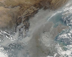
English: In this photo-like image, the thickest of the grey-brown haze conforms to the low-lying contours of the Yellow River Valley and the western half of the North China Plain near the Luliang Mountains. |
| Tarikh | |
| Sumber | NASA Earth Observatory |
| Pengarang | Jeff Schmaltz |
Image captured by the Moderate Resolution Imaging Spectroradiometer (MODIS) on NASA’s Aqua satellite. Image courtesy of the MODIS Rapid Response Team at NASA GSFC.
Perlesenan
| This file is in the public domain in the United States because it was solely created by NASA. NASA copyright policy states that "NASA material is not protected by copyright unless noted". (See Template:PD-USGov, NASA copyright policy page or JPL Image Use Policy.) | ||
 |
Warnings:
|
| Annotations | This image is annotated: View the annotations at Commons |
Sejarah fail
Klik pada tarikh/waktu untuk melihat rupa fail tersebut pada waktu itu.
| Tarikh/Waktu | Gambar kenit | Ukuran | Pengguna | Komen | |
|---|---|---|---|---|---|
| semasa | 11:27, 30 Oktober 2009 | | 5,600 × 4,400 (3.24 MB) | Originalwana | {{Information |Description={{en|1=In this photo-like image, the thickest of the grey-brown haze conforms to the low-lying contours of the Yellow River Valley and the western half of the North China Plain near the [[:en:Lüliang Mountains|Lulian |
Penggunaan fail
Laman berikut menggunakan fail ini:
Penggunaan fail sejagat
Fail ini digunakan oleh wiki-wiki lain yang berikut:
- Penggunaan di ar.wikipedia.org
- Penggunaan di en.wikipedia.org
- Penggunaan di fa.wikipedia.org
- Penggunaan di it.wikipedia.org
- Penggunaan di ja.wikipedia.org
- Penggunaan di test2.wikipedia.org
- Penggunaan di uk.wikipedia.org