Fail:Iditarod Trail BLM map.jpg
Tiada leraian lebih besar.
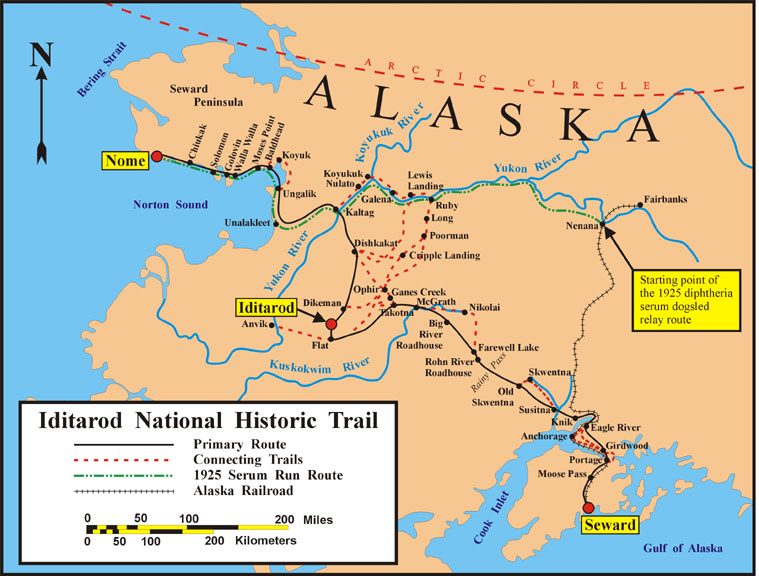
Iditarod_Trail_BLM_map.jpg (759 × 576 piksel, saiz fail: 85 KB, jenis MIME: image/jpeg)
Ringkasan
| Keterangan | Map of the historical Iditarod Trail and the current Iditarod National Historic Trail in Alaska, USA |
| Tarikh | |
| Sumber | U.S. Bureau of Land Management |
| Pengarang | U.S. Bureau of Land Management |
| Kebenaran (Penggunaan semula fail ini) |
public domain, as a U.S. federal government work |

|
This map image could be re-created using vector graphics as an SVG file. This has several advantages; see Commons:Media for cleanup for more information. If an SVG form of this image is available, please upload it and afterwards replace this template with
{{vector version available|new image name}}.
It is recommended to name the SVG file “Iditarod Trail BLM map.svg”—then the template Vector version available (or Vva) does not need the new image name parameter. |


Perlesenan
| This image is a work of a Bureau of Land Management* employee, taken or made as part of that person's official duties. As a work of the U.S. federal government, the image is in the public domain in the United States. *or predecessor organization |
Sejarah fail
Klik pada tarikh/waktu untuk melihat rupa fail tersebut pada waktu itu.
| Tarikh/Waktu | Gambar kenit | Ukuran | Pengguna | Komen | |
|---|---|---|---|---|---|
| semasa | 05:47, 9 Februari 2008 | | 759 × 576 (85 KB) | Delirium | {{Information |Description=Map of the historical Iditarod Trail and the current Iditarod National Historic Trail in Alaska, USA |Source=[http://www.blm.gov/ak/st/en/prog/sa/iditarod/inht_map.html U.S. Bureau of Land Management] |Date=2007 |Author=U.S. Bur |
Penggunaan fail
Laman berikut menggunakan fail ini:
Penggunaan fail sejagat
Fail ini digunakan oleh wiki-wiki lain yang berikut:
- Penggunaan di az.wikipedia.org
- Penggunaan di cs.wikipedia.org
- Penggunaan di de.wikipedia.org
- Penggunaan di en.wikipedia.org
- Penggunaan di en.wikivoyage.org
- Penggunaan di es.wikipedia.org
- Penggunaan di fr.wikipedia.org
- Iditarod Trail
- Course au sérum de 1925
- Discussion:Course au sérum de 1925
- Wikipédia:Le saviez-vous ?/Archives/2015
- Utilisateur:GhosterBot/BacASable/testStat/Visibilité des anecdotes (2015)
- Utilisateur:GhosterBot/BacASable/testStat/Visibilité des anecdotes (2015)/2015 02
- Wikipédia:Statistiques des anecdotes de la page d'accueil/Visibilité des anecdotes (2015)/2015 02
- Wikipédia:Statistiques des anecdotes de la page d'accueil/Visibilité des anecdotes (2015)
- Discussion:Course au sérum de 1925/LSV 16741
- Penggunaan di he.wikipedia.org
- Penggunaan di id.wikipedia.org
- Penggunaan di it.wikipedia.org
- Penggunaan di nl.wikipedia.org
- Penggunaan di pl.wikipedia.org
- Penggunaan di ru.wikipedia.org
- Penggunaan di simple.wikipedia.org
- Penggunaan di uk.wikipedia.org
- Penggunaan di vi.wikipedia.org
- Penggunaan di www.wikidata.org
- Penggunaan di zh.wikipedia.org