Fail:Japanese Empire - 1942.svg

Size of this PNG preview of this SVG file: 788 × 600 piksel. Leraian-leraian lain: 316 × 240 piksel | 631 × 480 piksel | 1,009 × 768 piksel | 1,280 × 974 piksel | 2,560 × 1,948 piksel | 1,100 × 837 piksel.
Fail asli (Fail SVG, ukuran dasar 1,100 × 837 piksel, saiz fail: 875 KB)
Ringkasan
| Keterangan |
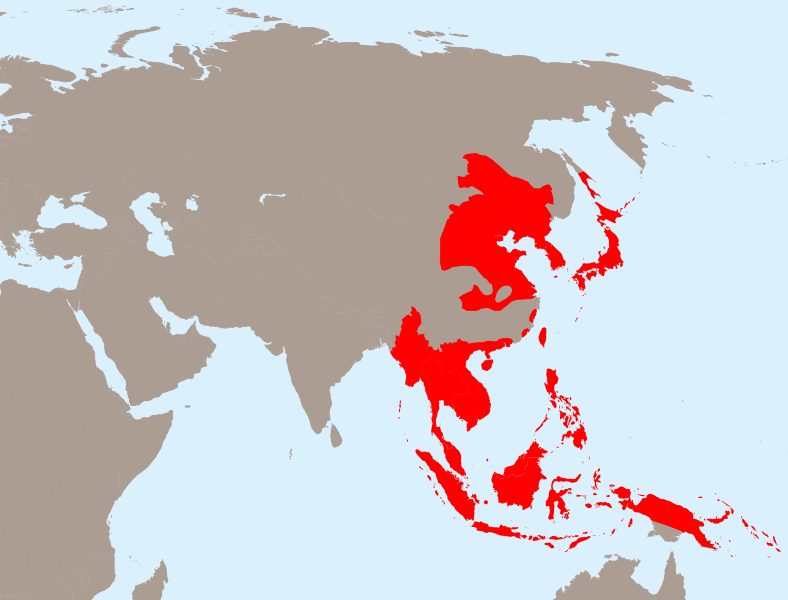
English: The Empire of Japan at its height in 1942.
Français : Japon 1942
Deutsch: Japanisches Reich 1942 |
| Tarikh | |
| Sumber | Own work based on: Empire of Japan (1868-1945).png by Mackay 86, Asie.svg by historicair and Japanese Empire2.png by Mackay 86 |
| Pengarang |
Vektor: |
| SVG genesis |
.png)
Perlesenan
Fail ini dilesenkan di bawah lesen Pengiktirafan-Perkongsian Serupa 3.0 Tidak Diport Creative Commons.
- Anda bebas:
- untuk berkongsi – untuk menyalin, mengedar dan memindah hasil kerja
- untuk mencampur semula – untuk menyesuaikan karya
- Di bawah syarat berikut:
- pengiktirafan – Anda mesti memberi penghargaan yang berpatutan, bekalkan pautan ke lesen, dan tunjukkan jika perubahan telah dibuat. Anda boleh lakukannya dalam sebarang cara yang munasabah, tetapi bukan dalam sebarang cara yang mencadangkan pemberi lesen mengendors anda atau penggunaan anda.
- perkongsian serupa – Jika anda mengubah, adun semula, atau menokok tambah bahan, anda mesti menyebarkan sumbangan anda di bawah lesen yang sama atau serasi dengan yang asal.
Log muat naik asal
This image is a derivative work of the following images:
- Empire of Japan (1868-1945).png licensed with PD-user-w
- 2010-04-13T05:49:21Z File Upload Bot (Magnus Manske) 1000x600 (183888 Bytes) {{BotMoveToCommons|en.wikipedia|year={{subst:CURRENTYEAR}}|month={{subst:CURRENTMONTHNAME}}|day={{subst:CURRENTDAY}}}} {{Information |Description={{en|The Empire of Japan at its height in 1942.}} |Source=Transferred from [ht
- Asie.svg licensed with PD-self
- 2006-11-23T21:09:53Z Historicair 1100x837 (902355 Bytes)
- 2006-11-23T20:25:19Z Historicair 1100x837 (902408 Bytes)
- 2006-11-22T22:59:34Z Historicair 1100x837 (898316 Bytes)
- 2006-11-21T18:36:45Z Historicair 1100x837 (897827 Bytes)
- 2006-11-20T20:31:48Z Historicair 1100x837 (816138 Bytes) {{Information |Description={{fr|1=Carte vierge de l'Asie }}{{en|1=Asia Blank map}} |Source=http://en.wikipedia.org/wiki/Image:BlankMap-World5.svg |Date=20/11/2006 |Author=~~~~ |Permission={{PD-self}} |other_versions= }} {{Atelier g
- Japanese Empire2.png licensed with Cc-by-sa-3.0-migrated, GFDL
- 2007-07-05T11:47:48Z Mahahahaneapneap 707x591 (32385 Bytes) pngcrushed
- 2007-05-27T01:31:13Z Gryffindor 707x591 (49084 Bytes) {{svg}} {{GFDL}} Modified version of [[:Image:Japanese_Empire.png]]. Fixed Ryukyu Islands, Sichuan, grammar in table. [[Category:Maps of the history of Japan]] [[Category:Maps of the history of Korea]] [[Category:Maps of th
- 2007-02-27T15:13:21Z Cristan 508x591 (37210 Bytes) Optimized using PNGOUT
- 2005-12-22T11:24:51Z Markalexander100 508x591 (47890 Bytes) {{GFDL}} Modified version of [[:Image:Japanese_Empire.png]]. Fixed Ryukyu Islands, Sichuan, grammar in table.
Uploaded with derivativeFX
Sejarah fail
Klik pada tarikh/waktu untuk melihat rupa fail tersebut pada waktu itu.
| Tarikh/Waktu | Gambar kenit | Ukuran | Pengguna | Komen | |
|---|---|---|---|---|---|
| semasa | 20:13, 31 Mac 2020 | | 1,100 × 837 (875 KB) | Esmu Igors | Northern part of the Sakhalin island was transferred from Japan to Soviet Russia in 1925, and the borders remained untouched until the end of WWII. Hence this territory should be omitted from the map. |
| 20:13, 31 Mac 2020 |  | 1,100 × 837 (904 KB) | Esmu Igors | Reverted to version as of 01:24, 25 April 2010 (UTC) (unsuccessful edit in the Inkscape) | |
| 20:11, 31 Mac 2020 |  | 1,100 × 837 (882 KB) | Esmu Igors | Northern part of the Sakhalin island was transferred from Japan to Soviet Russia in 1925, and the borders remained untouched until the end of WWII. Hence this territory should be omitted from the map. | |
| 01:24, 25 April 2010 |  | 1,100 × 837 (904 KB) | Ras67 | borders removed | |
| 21:44, 23 April 2010 |  | 1,100 × 837 (911 KB) | TastyCakes | Tweaked some borders and coloured some islands that I missed | |
| 21:29, 23 April 2010 |  | 1,100 × 837 (911 KB) | TastyCakes | {{Information |Description={{en|The Empire of Japan at its height in 1942.}} {{fr}}Carte vierge de l'Asie {{en}}Asia Blank map |Source=*File:Empire_of_Japan_(1868-1945).png *File:Asie.svg *File:Japanese_Empire2.png |Date=2010-04-23 21:26 |
.png)
Penggunaan fail
Laman berikut menggunakan fail ini:
Penggunaan fail sejagat
Fail ini digunakan oleh wiki-wiki lain yang berikut:
- Penggunaan di ar.wikipedia.org
- Penggunaan di bcl.wikipedia.org
- Penggunaan di be.wikipedia.org
- Penggunaan di ca.wikipedia.org
- Penggunaan di cs.wikipedia.org
- Penggunaan di de.wikipedia.org
- Penggunaan di en.wikipedia.org
- Penggunaan di es.wikipedia.org
- Penggunaan di fo.wikipedia.org
- Penggunaan di fr.wikipedia.org
- Penggunaan di id.wikipedia.org
- Penggunaan di it.wikipedia.org
- Penggunaan di ja.wikipedia.org
- Penggunaan di km.wikipedia.org
- Penggunaan di no.wikipedia.org
- Penggunaan di ru.wikipedia.org
- Penggunaan di sv.wikipedia.org
- Penggunaan di th.wikipedia.org
- Penggunaan di tl.wikipedia.org
- Penggunaan di uk.wikipedia.org
- Penggunaan di www.wikidata.org
- Penggunaan di zh-min-nan.wikipedia.org
- Penggunaan di zh-yue.wikipedia.org
- Penggunaan di zh.wikipedia.org
Lihat banyak lagi penggunaan sejagat bagi fail ini.