Fail:Lituya Bay overview.jpg
Tiada leraian lebih besar.
Lituya_Bay_overview.jpg (750 × 580 piksel, saiz fail: 111 KB, jenis MIME: image/jpeg)
Ringkasan
| Keterangan |
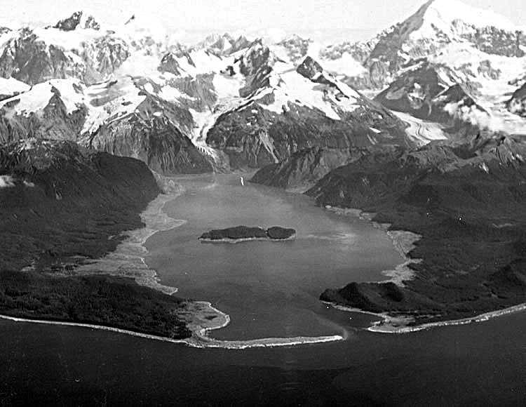
Deutsch: Die Bucht von Lituya einige Wochen nach dem Tsunami von 1958. Die zerstörten Waldgebiete sind deutlich als helle Flächen entlang des Ufers zu erkennen.
English: Lituya Bay a few weeks after the 1958 tsunami. The areas of destroyed forest are clearly recognizable as the light areas rimming the bay. |
| Tarikh | Summer 1958 |
| Sumber | USGS via [1] |
| Pengarang | D.J. Miller, United States Geological Survey |
| Versi lain | File:Lituya-Bay-overview-with-arrows.png |
Perlesenan
| This image or media file contains material based on a work of a United States Department of the Interior employee, created as part of that person's official duties. As a work of the U.S. federal government, such work is in the public domain in the United States. See the Department of the Interior copyright policy for more information. |  |
Sejarah fail
Klik pada tarikh/waktu untuk melihat rupa fail tersebut pada waktu itu.
| Tarikh/Waktu | Gambar kenit | Ukuran | Pengguna | Komen | |
|---|---|---|---|---|---|
| semasa | 05:06, 4 Mei 2009 | | 750 × 580 (111 KB) | Underpants~commonswiki | white balance, unsharp mask |
| 19:39, 16 Julai 2008 |  | 750 × 580 (55 KB) | Eleland | {{Information |Description={{en|1=Lituya Bay a few weeks after the 1958 tsunami. The areas of destroyed forest along the shorelines are clearly recognizable as the light areas rimming the bay. A fishing boat anchored in the cove at lower left was carried |
Penggunaan fail
Laman berikut menggunakan fail ini:
Penggunaan fail sejagat
Fail ini digunakan oleh wiki-wiki lain yang berikut:
- Penggunaan di ceb.wikipedia.org
- Penggunaan di cs.wikipedia.org
- Penggunaan di de.wikipedia.org
- Penggunaan di en.wikipedia.org
- Penggunaan di en.wikibooks.org
- Penggunaan di es.wikipedia.org
- Penggunaan di eu.wikipedia.org
- Penggunaan di fr.wikipedia.org
- Discussion:Baie Lituya
- Wikipédia:Le saviez-vous ?/Anecdotes proposées/Archivage des discussions/Archives/2015-4
- Wikipédia:Statistiques des anecdotes de la page d'accueil/Visibilité des anecdotes (2016)/2016 01
- Wikipédia:Statistiques des anecdotes de la page d'accueil/Visibilité des anecdotes (2016)
- Mégatsunami de 1958 de la baie Lituya
- Wikipédia:Le saviez-vous ?/Archives/2016
- Penggunaan di he.wikipedia.org
- Penggunaan di hu.wikipedia.org
- Penggunaan di it.wikipedia.org
- Penggunaan di ja.wikipedia.org
- Penggunaan di ko.wikipedia.org
- Penggunaan di pl.wikipedia.org
- Penggunaan di pt.wikipedia.org
- Penggunaan di ro.wikipedia.org
- Penggunaan di ru.wikipedia.org
- Penggunaan di uk.wikipedia.org
- Penggunaan di vi.wikipedia.org
- Penggunaan di www.wikidata.org
- Penggunaan di zh.wikipedia.org