Fail:Saint Anthony Falls aerial.jpg
Saint_Anthony_Falls_aerial.jpg (452 × 319 piksel, saiz fail: 56 KB, jenis MIME: image/jpeg)
Ringkasan
|
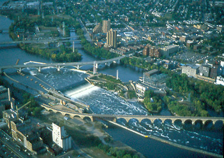
This is an image of a place or building that is listed on the National Register of Historic Places in the United States of America. Its reference number is 71000438. |
| Keterangan |
Aerial view of en:Saint Anthony Falls on the en:Mississippi River in en:Minneapolis, Minnesota. From http://www.nps.gov/parkoftheweek/photo-21.htm Image URL http://www.nps.gov/parkoftheweek/photos/miss_aerial.jpg The crossings of the river, starting from the top, are
Downtown Minneapolis is off the image to the left. A second lock and dam complex is off the image's lower right. en:Category:Images of Minneapolis, Minnesota en:Category:Images of Minnesota |
| Tarikh | 5 Disember 2004 (original upload date) |
| Sumber | Transferred from en.wikipedia to Commons. |
| Pengarang | The original uploader was Mulad at Inggeris Wikipedia. |
| Lokasi objek | | Paparkan imej ini dan imej berdekatan yang lain di: OpenStreetMap |
|---|
Perlesenan
| This image or media file contains material based on a work of a National Park Service employee, created as part of that person's official duties. As a work of the U.S. federal government, such work is in the public domain in the United States. See the NPS website and NPS copyright policy for more information. |
Log muat naik asal
- 2004-12-05 19:33 Mulad 452×319×8 (56836 bytes) Aerial view of [[Saint Anthony Falls]] in [[Minneapolis, Minnesota]]. From http://www.nps.gov/parkoftheweek/photo-21.htm Image URL http://www.nps.gov/parkoftheweek/photos/miss_aerial.jpg {{PD-USGov-NPS}}
Sejarah fail
Klik pada tarikh/waktu untuk melihat rupa fail tersebut pada waktu itu.
| Tarikh/Waktu | Gambar kenit | Ukuran | Pengguna | Komen | |
|---|---|---|---|---|---|
| semasa | 01:38, 16 Januari 2007 | | 452 × 319 (56 KB) | MECU | {{Information |Description=Aerial view of en:Saint Anthony Falls on the en:Mississippi River in en:Minneapolis, Minnesota. From http://www.nps.gov/parkoftheweek/photo-21.htm Image URL http://www.nps.gov/parkoftheweek/photos/miss_aerial.jpg |
Penggunaan fail
Laman berikut menggunakan fail ini:
Penggunaan fail sejagat
Fail ini digunakan oleh wiki-wiki lain yang berikut:
- Penggunaan di ar.wikipedia.org
- Penggunaan di ba.wikipedia.org
- Penggunaan di cs.wikipedia.org
- Penggunaan di de.wikipedia.org
- Penggunaan di en.wikipedia.org
- Penggunaan di es.wikipedia.org
- Penggunaan di fa.wikipedia.org
- Penggunaan di fr.wikipedia.org
- Penggunaan di he.wikipedia.org
- Penggunaan di hy.wikipedia.org
- Penggunaan di no.wikipedia.org
- Penggunaan di ru.wikipedia.org
- Penggunaan di simple.wikipedia.org
- Penggunaan di sw.wikipedia.org
- Penggunaan di ta.wikipedia.org
- Penggunaan di tt.wikipedia.org
- Penggunaan di vep.wikipedia.org
- Penggunaan di vi.wikipedia.org
- Penggunaan di www.wikidata.org
- Penggunaan di zh.wikipedia.org