Fail:Tidal Bore - geograph.org.uk - 324581.jpg
Tiada leraian lebih besar.
Tidal_Bore_-_geograph.org.uk_-_324581.jpg (640 × 461 piksel, saiz fail: 77 KB, jenis MIME: image/jpeg)
Ringkasan
| Keterangan |
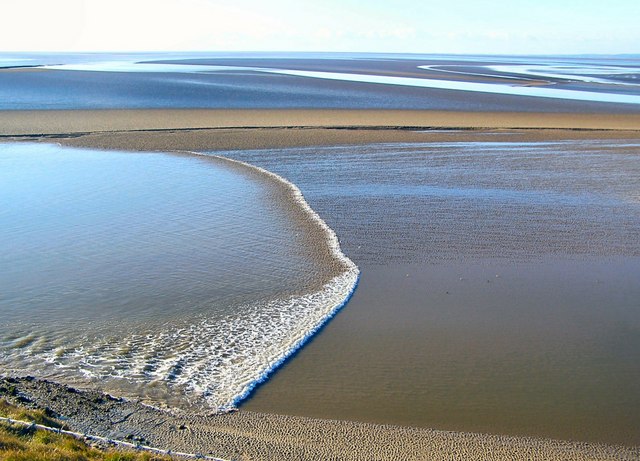
English: Tidal Bore The channels are constantly changing and consequently not shown on the OS map. Here the tidal bore is coming up a channel, one of several such channels in the estuary, on its way to Arnside some 8km away as the tide flows. It took 2 hours and 5 minutes to reach the viaduct at Arnside (shown in 324585) from this point. |
| Tarikh | |
| Sumber | From geograph.org.uk |
| Pengarang | Arnold Price |
| Pengiktirafan (required by the license) | Arnold Price / Tidal Bore / |
| Lokasi objek | | Paparkan imej ini dan imej berdekatan yang lain di: OpenStreetMap |
|---|
_heading:202.00&language=ms)
Perlesenan

|
This image was taken from the Geograph project collection. See this photograph's page on the Geograph website for the photographer's contact details. The copyright on this image is owned by Arnold Price and is licensed for reuse under the Creative Commons Attribution-ShareAlike 2.0 license.
|
Fail ini dilesenkan di bawah lesen Pengiktirafan-Perkongsian Serupa 2.0 Umum Creative Commons.
Pengiktirafan: Arnold Price
- Anda bebas:
- untuk berkongsi – untuk menyalin, mengedar dan memindah hasil kerja
- untuk mencampur semula – untuk menyesuaikan karya
- Di bawah syarat berikut:
- pengiktirafan – Anda mesti memberi penghargaan yang berpatutan, bekalkan pautan ke lesen, dan tunjukkan jika perubahan telah dibuat. Anda boleh lakukannya dalam sebarang cara yang munasabah, tetapi bukan dalam sebarang cara yang mencadangkan pemberi lesen mengendors anda atau penggunaan anda.
- perkongsian serupa – Jika anda mengubah, adun semula, atau menokok tambah bahan, anda mesti menyebarkan sumbangan anda di bawah lesen yang sama atau serasi dengan yang asal.
Sejarah fail
Klik pada tarikh/waktu untuk melihat rupa fail tersebut pada waktu itu.
| Tarikh/Waktu | Gambar kenit | Ukuran | Pengguna | Komen | |
|---|---|---|---|---|---|
| semasa | 19:45, 30 Disember 2010 | | 640 × 461 (77 KB) | GeographBot | == {{int:filedesc}} == {{Information |description={{en|1=Tidal Bore The channels are constantly changing and consequently not shown on the OS map. Here the tidal bore is coming up a channel, one of several such channels in the estuary, on its way to Arnsi |
Penggunaan fail
Laman berikut menggunakan fail ini:
Penggunaan fail sejagat
Fail ini digunakan oleh wiki-wiki lain yang berikut:
- Penggunaan di ar.wikipedia.org
- Penggunaan di bn.wikipedia.org
- Penggunaan di en.wikipedia.org
- Penggunaan di es.wikipedia.org
- Penggunaan di fa.wikipedia.org
- Penggunaan di fr.wikipedia.org
- Penggunaan di fr.wikiversity.org
- Penggunaan di ga.wikipedia.org
- Penggunaan di he.wikipedia.org
- Penggunaan di oc.wikipedia.org
- Penggunaan di ro.wikipedia.org
- Penggunaan di sl.wikipedia.org
- Penggunaan di tr.wikipedia.org
- Penggunaan di uk.wikipedia.org
- Penggunaan di zh-yue.wikipedia.org