Fail:US Navy 110320-M-0145H-063 A large ferry boat rests inland amidst destroyed houses after a 9.0 earthquake and subsequent tsunami struck Japan March.jpg
Saiz pralihat ini: 800 × 533 piksel. Leraian-leraian lain: 320 × 213 piksel | 640 × 427 piksel | 1,023 × 682 piksel.
Fail asli (1,023 × 682 piksel, saiz fail: 221 KB, jenis MIME: image/jpeg)
Ringkasan
| Keterangan |
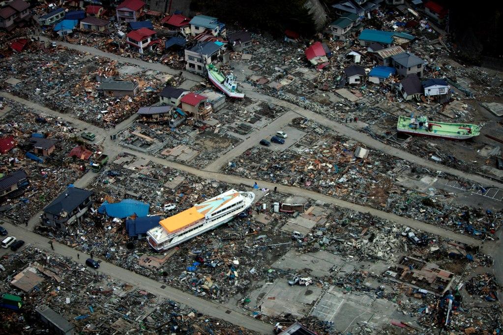
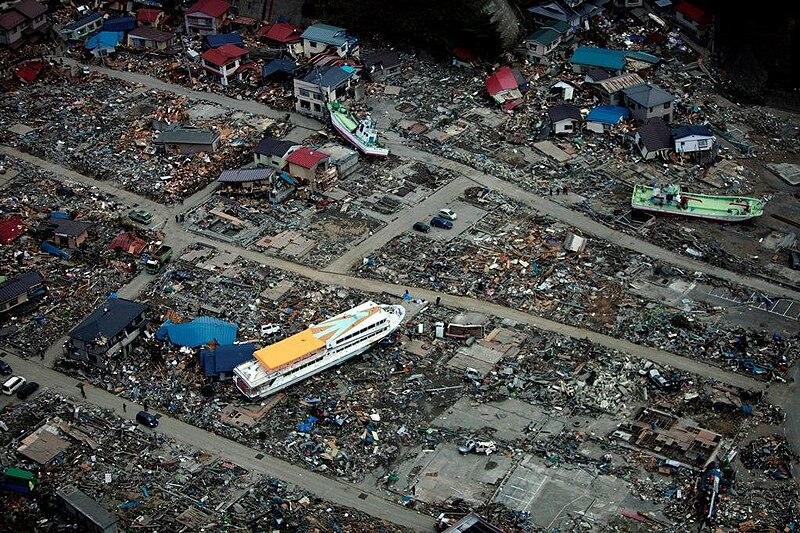
English: Miyako, Iwate Prefecture Japan (March 20, 2011). -- A large ferry boat rests inland amidst destroyed houses after a 9.0 earthquake and subsequent tsunami struck Japan March 11. As part of Operation Tomodachi, the 31st Marine Expeditionary Unit delivered much-needed relief supplies to the Japanese citizens in the area. (U.S. Marine Corps photo by Lance Cpl. Garry Welch/Released)
|
|||
| Tarikh | Taken on 20 Mac 2011 | |||
| Sumber |
|
|||
| Pengarang | U.S. Marine Corps photo by Lance Cpl. Garry Welch |

| Lokasi kamera | | Paparkan imej ini dan imej berdekatan yang lain di: OpenStreetMap |
|---|
Perlesenan
This file is a work of a sailor or employee of the U.S. Navy, taken or made as part of that person's official duties. As a work of the U.S. federal government, it is in the public domain in the United States.
|
 | |
| Fail ini telah dikenal pasti sebagai bebas daripada sekatan-sekatan yang dikenali mengikut undang-undang hak cipta, termasuk semua hak berkaitan dan berjiran. | ||
Sejarah fail
Klik pada tarikh/waktu untuk melihat rupa fail tersebut pada waktu itu.
| Tarikh/Waktu | Gambar kenit | Ukuran | Pengguna | Komen | |
|---|---|---|---|---|---|
| semasa | 02:08, 30 Mac 2011 | | 1,023 × 682 (221 KB) | BotMultichillT | == {{int:filedesc}} == {{Information |description={{en|1=AICHI, Japan (March 20, 2011) A large ferry boat rests inland amidst destroyed houses after a 9.0 earthquake and subsequent tsunami struck Japan March 11. As part of Operation Tomodachi, the 31st Ma |
Penggunaan fail
Laman berikut menggunakan fail ini:
Penggunaan fail sejagat
Fail ini digunakan oleh wiki-wiki lain yang berikut:
- Penggunaan di de.wikipedia.org
- Penggunaan di en.wikipedia.org
- Penggunaan di en.wikivoyage.org
- Penggunaan di ja.wikipedia.org
- Penggunaan di ja.wikinews.org
- Penggunaan di ko.wikipedia.org
- Penggunaan di pt.wikipedia.org
- Penggunaan di sl.wikipedia.org
- Penggunaan di sr.wikipedia.org
- Penggunaan di sv.wikipedia.org
- Penggunaan di ta.wikipedia.org