Garisan Nazca
Koordinat: 14°43′00″S 75°08′00″W / 14.71667°S 75.13333°W
Garisan Nazca (Quechua: Naska siq'ikuna, Sepanyol: Líneas de Nazca) merupakan kumpulan parit bumi yang sangat besar terletak di Gurun Nazca, selatan Peru. Ia dikaji mula terwujud antara 500 SM dan 500 TM[1] hasil pengikisan[2] lapisan atas merah jambu bersalut besi oksida merah untuk mendedahkan tanah bawahnya yang berwarna kuning kelabu.[1] Garisan-garisan ini adakalanya membentuk rupa yang paling baik dilihat dari udara (~ 1,500 kaki) namun boleh juga dari kaki bukit dan tempat-tempat tinggi di sekitarnya.[3][4][5] Kedudukan ia yang terasing serta beriklim kering tanpa angin dan stabil menjadikan corak-corak ini dipelihara secara semulajadi.
 Gambar udara 1953 oleh Maria Reiche, salah seorang ahli arkeologi pertama yang mempelajari garisan | |
| Maklumat am | |
|---|---|
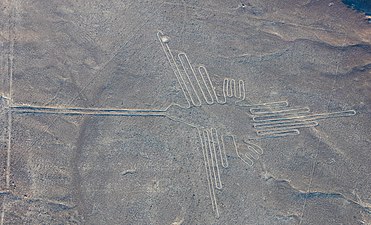
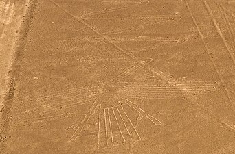
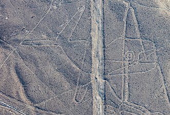
| Termasuklah | Nazca Cat geoglyph Nazca Condor Geoglyph Nazca Dog geoglyph Nazca Flamingo geoglyph Nazca Flower geoglyph Nazca Frigate Bird geoglyph Nazca Hands geoglyph Nazca Hummingbird geoglyph Nazca Lizard geoglyph Nazca Monkey geoglyph Nazca Owlman geoglyph Nazca Parrot geoglyph Nazca Small Spiral geoglyph Nazca Spider geoglyph Nazca Tree geoglyph Nazca Whale geoglyph Nazca cactus geoglyph |
| Inskripsi | 1994 (sesi ke-18) |
| Keluasan | 75,358.47 ha |
| Maklumat lokasi | |
| Lokasi | Coastal desert of Peru, El Ingenio District, Gurun Sechura, Wilayah Ica, Nasca Province, Peru |
| Koordinat | 14°43′33″S 75°8′55″W / 14.72583°S 75.14861°W |
.svg) Garisan Nazca (Bumi) | |
 | |
sunting · sunting di Wikidata | |
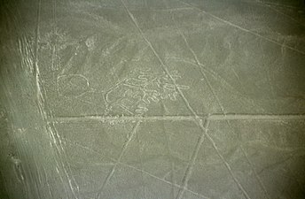
Bentuk-bentuk yang dicakar pada tanah ini berbagai rupa; ratusan garisan didapati menghasilkan bentuk geometri mudah, namun ada lebih daripada 70 reka bentuk menyerupai haiwan seperti unggas, labah-labah, ikan, llama, jaguar, monyet, anjing dan manusia. Malah, bentuk lain termasuk pokok dan bunga turut boleh didapati. Kesemua corak-corak ini biasanya dibuat dari satu garis yang berterusan. Corak yang terbesar dijumpai berkeluasan kira-kira 370 m (1,200 kaki).[6] Para cendekiawan berbeza pendapat mengenai maksud dan tujuan corak-corak ini, tetapi pada umumnya dpersetujui sebagai berkepentingan terhadap agama anutan masyarakat setempat.[7][8][9][10]
Sehingga 2012, garisan dikatakan semakin merosot kerana kemasukan penduduk setinggan mendiami tanah.[11] Kawasan sekitar ini disenaraikan sebagai suatu Tapak Warisan Dunia oleh UNESCO tahun 1994.
Gambaran utama sunting
Kesemua garisan-garisan ini terletak di sebuah penara tinggi merentas sejauh 80 km dari Nazca ke Palpa dalam kawasan Pampas de Jumana, 400 km dari selatan Lima.
Corak-corak ini mula dicatatkan dalam pemerhatian seorang conquistador, Pedro Cieza de León dalam buku 1554, di mana Pedro menggambarkan corak-corak tersebut sebagai penanda atau "isyarat" (señales) suatu jalan denai.[12] Kawasan ini mula diterokai secara mendalam oleh ahli arkeologi Peru, Toribio Mejía Xesspe yang menemukan ia pada 1927, penemuan ini mula dihebahkan secara meluas dalam suatu sidang penyelidikan di Lima tahun 1939.[13]
Imej sunting
-
 Kelicap
 -
 Kondor
 -
 Heron
Heron -
 Paus
Paus -
 Manusia
 -
 Labah-labah
 -
 Undan
Undan -
 Anjing
 -
 Pokok
Pokok -
 Monyet
 -
 Glif Fitomorfik
 -
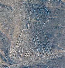 Tangan


Catatan sunting
- ^ a b "Nazca Lines". Guía Go2peru (dalam bahasa Inggeris). 22 Februari 2017. Dicapai pada 29 Oktober 2018. Cite has empty unknown parameter:
|dead-url=(bantuan) - ^ "The Nasca Lines Are One of Peru's Mysteries". National Geographic. 8 November 2010. Dicapai pada 29 Oktober 2018. Cite has empty unknown parameter:
|dead-url=(bantuan) - ^ Gardner's Art Through the Ages: Ancient, medieval, and non-European art. Harcourt Brace Jovanovich; 1 January 1991. ISBN 978-0-15-503770-0.
- ^ Hinman, Bonnie. Mystery of the Nazca Lines. ABDO; 1 January 2016. ISBN 978-1-68077-242-5. p. 6–.
- ^ Anthony F. Aveni. Between the Lines: The Mystery of the Giant Ground Drawings of Ancient Nasca, Peru. University of Texas Press; 2000. ISBN 978-0-292-70496-1. p. 88–.
- ^ Golomb, Jason. "Nasca Lines – The Sacred Landscape". National Geographic. Diarkibkan daripada yang asal pada 2015-09-10. Dicapai pada 23 Ogos 2016.
- ^ Helaine Selin. Nature Across Cultures: Views of Nature and the Environment in Non-Western Cultures. Springer Science & Business Media; 17 April 2013. ISBN 978-94-017-0149-5. p. 286–.
- ^ Richard A. Freund. Digging Through History: Archaeology and Religion from Atlantis to the Holocaust. Rowman & Littlefield; 27 October 2016. ISBN 978-1-4422-0883-4. p. 22–.
- ^ Mary Strong. Art, Nature, and Religion in the Central Andes: Themes and Variations from Prehistory to the Present. University of Texas Press; 1 May 2012. ISBN 978-0-292-73571-2. p. 33–.
- ^ Religion and the Environment. Palgrave Macmillan UK; 3 June 2016. ISBN 978-0-230-28634-4. p. 110–.
- ^ Taj, Mitra (August 15, 2012). "Pigs and squatters threaten Peru's Nazca lines". Reuters. Diarkibkan daripada yang asal pada 2012-08-16. Dicapai pada August 15, 2012.
- ^ page 141 Pedro Cieza de León, La Chronica del Peru (The Chronicle of Peru), (Antwerp, (Belgium): Martin Nucio, 1554), p. 141. Note: Cieza discussed the Nazca region of Peru and said that "y por algunas partes delos arenales se veen señales, paraque atinen el camino que han de lleuar" ("and in some parts of the desert are seen signals, so that they [i.e., the Indians] find the path that has to be taken").
- ^ Mejía Xesspe, Toribio (1939) "Acueductos y caminos antiguos de la hoya del Río Grande de Nazca" (Akueduk dan jalan purba lembah Rio Grande di Nazca), Actas y Trabajos Cientificos del 27 Congreso Internacional de Americanistas, 1: 559–569.
Rujukan sunting
- Aveni, Anthony F. (ed.) (1990). The Lines of Nazca. Philadelphia: American Philosophical Society. ISBN 0-87169-183-3
- Haughton, Brian. (2007). Hidden History: Lost Civilizations, Secret Knowledge, and Ancient Mysteries. Career Press. ISBN 1-56414-897-1
- Johnson, Emma. 2007. The 'Mysterious' Nazca Lines. PARA Web Bibliography B-01.
- Johnson, D. W., Proulx. D. A., Mabee, S. B. (2002). The correlation between geoglyphs and subterranean water resources in the Rio Grande de Nasca drainage. In Silvermann H. & Isbell W. H. (Ed.), Andean Archaeology II: art, landscape, and society. New York, Kluwer Academic, pp. 307-332.
- Kosok, Paul (1965). Life, Land and Water in Ancient Peru, Brooklyn: Long Island University Press.
- Lambers, Karsten (2006). The Geoglyphs of Palpa, Peru: Documentation, Analysis, and Interpretation. Lindensoft Verlag, Aichwald/Germany. ISBN 3-929290-32-4
- Masini, Nicola, Orefici, Giuseppe, Danese, M., Pecci, A., Scavone, M., Lasaponara, R. (2016). Cahuachi and Pampa de Atarco: Towards Greater Comprehension of Nasca Geoglyphs. In: Lasaponara R., Masini N., Orefici G. (Eds). The Ancient Nasca World New Insights from Science and Archaeology. Springer International Publishing, pp. 239-278.
- Nickell, Joe. 1983. Skeptical Inquirer The Nazca Lines Revisited: Creation of a Full-Sized Duplicate.
- Reindel, Marcus, Wagner, Günther A. (2009) (Eds.) New Technologies for Archaeology: Multidisciplinary Investigations in Nasca and Palpa, Peru. Springer, Heidelberg, Berlin
- Reinhard, Johan (1996) (6th ed.) The Nazca Lines: A New Perspective on their Origin and Meaning. Lima: Los Pinos. ISBN 84-89291-17-9
- Sauerbier, Martin. GIS-based Management and Analysis of the Geoglyphs in the Palpa Region. ETH (2009). doi:10.3929/ethz-a-005940066.
- Stierlin, Henri (1983). La Clé du Mystère. Paris: Albin Michel. ISBN 2-226-01864-6
Pautan luar sunting
| Wikimedia Commons mempunyai media berkaitan Garisan Nazca |