Fail:MountGriggs.jpg

Saiz pralihat ini: 800 × 538 piksel. Leraian-leraian lain: 320 × 215 piksel | 640 × 430 piksel | 1,024 × 688 piksel.
Fail asli (1,024 × 688 piksel, saiz fail: 180 KB, jenis MIME: image/jpeg)
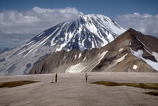
| Keterangan | Mount Griggs volcano, 2,317-m (7,602 ft)-high, here seen from the west rim of Katmai caldera, lies 10 km (6 mi) behind the volcanic arc defined by other Katmai group volcanoes. Although no historic eruptions have been reported from Mount Griggs, vigorously active fumaroles persist in a summit crater and along the upper southwest flank. The slopes of Mount Griggs are heavily mantled by fallout from the 1912 eruption of Novarupta volcano. View is to the northwest. | |||
| Tarikh | ||||
| Sumber | http://pubs.usgs.gov/dds/dds-40/ | |||
| Pengarang | R. McGimsey, U.S. Geological Survey | |||
| Kebenaran (Penggunaan semula fail ini) |
|
Sejarah fail
Klik pada tarikh/waktu untuk melihat rupa fail tersebut pada waktu itu.
| Tarikh/Waktu | Gambar kenit | Ukuran | Pengguna | Komen | |
|---|---|---|---|---|---|
| semasa | 13:25, 20 Januari 2005 | | 1,024 × 688 (180 KB) | GarciaB~commonswiki | Mount Griggs Volcano, Alaska |
Penggunaan fail
Laman berikut menggunakan fail ini:
Penggunaan fail sejagat
Fail ini digunakan oleh wiki-wiki lain yang berikut:
- Penggunaan di arz.wikipedia.org
- Penggunaan di ca.wikipedia.org
- Penggunaan di ceb.wikipedia.org
- Penggunaan di de.wikipedia.org
- Penggunaan di en.wikipedia.org
- Penggunaan di es.wikipedia.org
- Penggunaan di fr.wikipedia.org
- Penggunaan di ko.wikipedia.org
- Penggunaan di lld.wikipedia.org
- Penggunaan di no.wikipedia.org
- Penggunaan di ru.wikipedia.org
- Penggunaan di uk.wikipedia.org
- Penggunaan di ur.wikipedia.org
- Penggunaan di www.wikidata.org
- Penggunaan di zh.wikipedia.org