Fail:ElectoralCollege2016.svg

Fail asli (Fail SVG, ukuran dasar 1,020 × 593 piksel, saiz fail: 30 KB)
| U.S. presidential election maps (SVG) |
| See also: National Atlas maps (png) |
|
1789 · 1792 · 1796 · 1800 · 1804 · 1808 · 1812 · 1816 · 1820 · 1824 · 1828 · 1832 · 1836 · 1840 · 1844 · 1848 · 1852 · 1856 · 1860 · 1864 · 1868 · 1872 · 1876 · 1880 · 1884 · 1888 · 1892 · 1896 · 1900 · 1904 · 1908 · 1912 · 1916 · 1920 · 1924 · 1928 · 1932 · 1936 · 1940 · 1944 · 1948 · 1952 · 1956 · 1960 · 1964 · 1968 · 1972 · 1976 · 1980 · 1984 · 1988 · 1992 · 1996 · 2000 · 2004 · 2008 · 2012 · 2016 · 2020 · 2024 |
Ringkasan
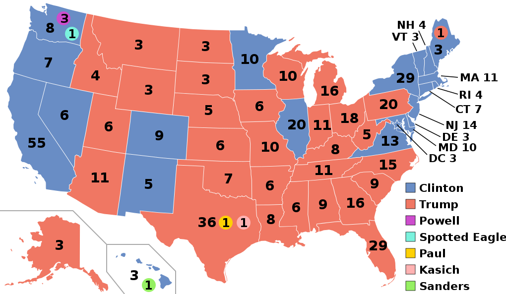
| Keterangan |
English: Electoral college map for the 2016 United States presidential election (note: Nebraska and Maine split their EVs by congressional district). |
||||
| Tarikh | |||||
| Sumber | 2012 Electoral College map | ||||
| Pengarang | Gage | ||||
| Versi lain |
|
||||
| SVG genesis |

.svg)


.svg)
.svg)


Perlesenan
- Anda bebas:
- untuk berkongsi – untuk menyalin, mengedar dan memindah hasil kerja
- untuk mencampur semula – untuk menyesuaikan karya
- Di bawah syarat berikut:
- pengiktirafan – Anda mesti memberi penghargaan yang berpatutan, bekalkan pautan ke lesen, dan tunjukkan jika perubahan telah dibuat. Anda boleh lakukannya dalam sebarang cara yang munasabah, tetapi bukan dalam sebarang cara yang mencadangkan pemberi lesen mengendors anda atau penggunaan anda.
- perkongsian serupa – Jika anda mengubah, adun semula, atau menokok tambah bahan, anda mesti menyebarkan sumbangan anda di bawah lesen yang sama atau serasi dengan yang asal.
Sejarah fail
Klik pada tarikh/waktu untuk melihat rupa fail tersebut pada waktu itu.
| Tarikh/Waktu | Gambar kenit | Ukuran | Pengguna | Komen | |
|---|---|---|---|---|---|
| semasa | 03:22, 27 November 2020 | | 1,020 × 593 (30 KB) | Politicsfan4 | Updated placement of ME-2's electoral vote for consistency with 2020 map |
| 01:22, 5 Ogos 2020 |  | 1,020 × 593 (30 KB) | Nojus R | Reverted to version as of 07:42, 13 January 2019 (UTC) it looks so weird when every other map uses a different font | |
| 19:31, 10 Disember 2019 |  | 1,020 × 593 (30 KB) | IagoQnsi | switching font to Arial, as it looks less-ugly in the server-side rendering // Editing SVG source code using c:User:Rillke/SVGedit.js | |
| 07:42, 13 Januari 2019 |  | 1,020 × 593 (30 KB) | Newfraferz87 | (minor) | |
| 02:50, 20 November 2018 |  | 1,020 × 593 (30 KB) | Newfraferz87 | *DC | |
| 02:35, 20 November 2018 |  | 1,020 × 593 (30 KB) | Newfraferz87 | Simplify further: coordinates & fills, following this | |
| 14:16, 18 Januari 2017 |  | 1,020 × 593 (36 KB) | Newfraferz87 | Shrink size using relative line coordinates. Thanks for the border corrections. | |
| 09:20, 17 Januari 2017 |  | 1,020 × 593 (43 KB) | Karlfk | Better borderlines, esp. OH/WV/PA triangle or ID/MT border | |
| 03:14, 12 Januari 2017 |  | 1,020 × 593 (36 KB) | PalmerTheGolfer | Reverted to version as of 00:56, 3 January 2017 (UTC) Font of numbers and State line consistency with prior elections more important than a non-existent Libretarian faithless elector change | |
| 22:50, 10 Januari 2017 |  | 1,020 × 593 (36 KB) | Maproom | Changed font to Liberation Sans, in the hope of avoiding the problem of "Eagle" extending off the end of the image |
.svg)
Penggunaan fail
2 buah laman berikut menggunakan fail ini:
Penggunaan fail sejagat
Fail ini digunakan oleh wiki-wiki lain yang berikut:
- Penggunaan di af.wikipedia.org
- Penggunaan di ang.wikipedia.org
- Penggunaan di ar.wikipedia.org
- Penggunaan di arz.wikipedia.org
- Penggunaan di be.wikipedia.org
- Penggunaan di bg.wikipedia.org
- Penggunaan di bn.wikipedia.org
- Penggunaan di bs.wikipedia.org
- Penggunaan di ca.wikipedia.org
- Penggunaan di cdo.wikipedia.org
- Penggunaan di cs.wikipedia.org
- Penggunaan di cy.wikipedia.org
- Penggunaan di da.wikipedia.org
- Penggunaan di de.wikipedia.org
- Penggunaan di dty.wikipedia.org
- Penggunaan di el.wikipedia.org
- Penggunaan di en.wikipedia.org
- Donald Trump
- Electoral vote changes between United States presidential elections
- List of United States presidential election results by state
- Presidency of Barack Obama
- 2016 United States presidential election
- United States presidential election
- 2016 Democratic Party presidential candidates
- 2016 Democratic Party presidential primaries
- 2016 Republican Party presidential candidates
- 2016 Republican Party presidential primaries
- Third party and independent candidates for the 2016 United States presidential election
- 2016 United States elections
- User:ArcMachaon/sandbox
- User:Mandruss/sandbox
- User:Visigoethe/sandbox
- User:Machinekng/sandbox
Lihat banyak lagi penggunaan sejagat bagi fail ini.