Fail:Markagunt Plateau.jpg
Tiada leraian lebih besar.
Markagunt_Plateau.jpg (640 × 431 piksel, saiz fail: 96 KB, jenis MIME: image/jpeg)
| Keterangan |
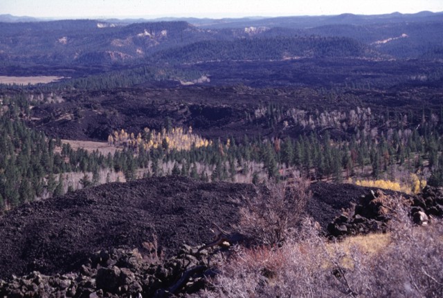
Black Rock Desert volcanic field — Markagunt Plateau.
|
|||
| Tarikh | ||||
| Sumber | http://www.volcano.si.edu/world/volcano.cfm?vnum=1207-04-&volpage=photos&photo=045096 | |||
| Pengarang | Lee Siebert (Smithsonian Institution) | |||
| Kebenaran (Penggunaan semula fail ini) |
|
Sejarah fail
Klik pada tarikh/waktu untuk melihat rupa fail tersebut pada waktu itu.
| Tarikh/Waktu | Gambar kenit | Ukuran | Pengguna | Komen | |
|---|---|---|---|---|---|
| semasa | 00:44, 29 Januari 2011 | | 640 × 431 (96 KB) | Michael Metzger | {{Information |Description=Blocky unvegetated lava flows known as the Black Rock Desert extend from near Miller Knoll to the SE. These flows, which also extend NE to near Panguitch Lake, are among the youngest features of the Markagunt Plateau volcanic fi |
Penggunaan fail
Laman berikut menggunakan fail ini:
Penggunaan fail sejagat
Fail ini digunakan oleh wiki-wiki lain yang berikut:
- Penggunaan di ceb.wikipedia.org
- Penggunaan di de.wikipedia.org
- Penggunaan di en.wikipedia.org
- Penggunaan di he.wikipedia.org
- Penggunaan di no.wikipedia.org
- Penggunaan di ru.wikipedia.org
- Penggunaan di www.wikidata.org