Fail:Maskat & Oman map.png

Saiz pralihat ini: 567 × 599 piksel. Leraian-leraian lain: 227 × 240 piksel | 454 × 480 piksel | 763 × 806 piksel.
Fail asli (763 × 806 piksel, saiz fail: 21 KB, jenis MIME: image/png)

|
This map image could be re-created using vector graphics as an SVG file. This has several advantages; see Commons:Media for cleanup for more information. If an SVG form of this image is available, please upload it and afterwards replace this template with
{{vector version available|new image name}}.
It is recommended to name the SVG file “Maskat & Oman map.svg”—then the template Vector version available (or Vva) does not need the new image name parameter. |
| Keterangan |
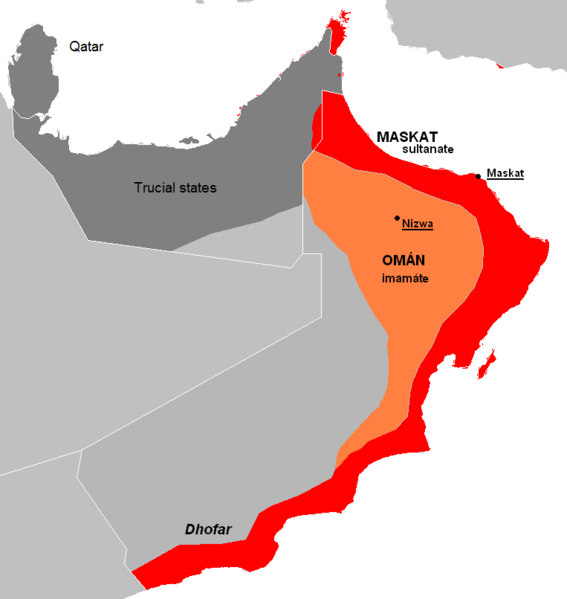
English: The approximate map of historic state of Mascat and Oman.
Čeština: Přibližná mapa historického státu Maskat a Omán |
| Tarikh | (UTC) |
| Sumber | |
| Pengarang |
|
| Versi lain | العربيَّة |
| Ini adalah gambar sentuh, ini bermakna bahawa ia telah didigitalkan dari versi asal. Modifikasi: de facto new map, viz. description. Versi asal boleh dilihat di sini: Al Hajar mountain woodlands map.png. Modifications made by Kolomaznik.
|
| Saya selaku pemegang hak cipta karya ini melepaskan karya ini ke dalam domain awam di seluruh dunia. Di sesetengah negara, undang-undangnya mungkin tidak mengizinkan; jika begitu: Saya memberi sesiapa sahaja hak untuk menggunakan karya ini untuk apa jua tujuan, tanpa sebarang syarat, melainkan undang-undang menetapkan syarat-syarat sedemikian. |
Log muat naik asal
This image is a derivative work of the following images:
- File:AT1306_map.png licensed with PD-self
- 2008-02-27T09:16:44Z Doreano 763x806 (23794 Bytes) {{Information |Description=Gulf of Oman desert and semi-desert ecoregion map |Source=self-made |Date=2008/2/27 |Author= [[User:Altatoron|Altatoron]] |Permission= |other_versions= }} [[Category:Biomes]] [[Category:Biogeography
- File:AT0801_map.png licensed with PD-self
- 2008-02-27T09:10:47Z Doreano 676x806 (18852 Bytes) {{Information |Description=Al Hajar montane woodlands ecoregion map |Source=self-made |Date=2008/2/27 |Author= [[User:Altatoron|Altatoron]] |Permission= |other_versions= }} [[Category:Biomes]] [[Category:Biogeography]] [[Cate
Uploaded with derivativeFX
Sejarah fail
Klik pada tarikh/waktu untuk melihat rupa fail tersebut pada waktu itu.
| Tarikh/Waktu | Gambar kenit | Ukuran | Pengguna | Komen | |
|---|---|---|---|---|---|
| semasa | 22:36, 7 Julai 2015 | | 763 × 806 (21 KB) | History of Persia | Made it easier to understand. |
| 19:06, 28 Mei 2010 |  | 763 × 806 (27 KB) | Kolomaznik | {{Information |Description={{en}}The approximate map of historic state of Mascat and Oman. {{cs}}Přibližná mapa historického státu Maskat a Omán |Source=*File:AT1306_map.png *File:AT0801_map.png |Date=2010-05-28 19:02 (UTC) |Author=*[[:F |
Penggunaan fail
Laman berikut menggunakan fail ini:
Penggunaan fail sejagat
Fail ini digunakan oleh wiki-wiki lain yang berikut:
- Penggunaan di ar.wikipedia.org
- Penggunaan di az.wikipedia.org
- Penggunaan di cs.wikipedia.org
- Penggunaan di de.wikipedia.org
- Penggunaan di el.wikipedia.org
- Penggunaan di en.wikipedia.org
- Penggunaan di es.wikipedia.org
- Penggunaan di eu.wikipedia.org
- Penggunaan di fa.wikipedia.org
- Penggunaan di fi.wikipedia.org
- Penggunaan di fr.wikipedia.org
- Penggunaan di he.wikipedia.org
- Penggunaan di id.wikipedia.org
- Penggunaan di it.wikipedia.org
- Penggunaan di ko.wikipedia.org
- Penggunaan di mn.wikipedia.org
- Penggunaan di nl.wikipedia.org
- Penggunaan di pl.wikipedia.org
- Penggunaan di pt.wikipedia.org
- Penggunaan di ru.wikipedia.org
- Penggunaan di sl.wikipedia.org
- Penggunaan di th.wikipedia.org
- Penggunaan di tr.wikipedia.org
- Penggunaan di uk.wikipedia.org
- Penggunaan di vi.wikipedia.org
- Penggunaan di www.wikidata.org
- Penggunaan di zh.wikipedia.org
Lihat banyak lagi penggunaan sejagat bagi fail ini.