Fail:PearlHarborCarrierChart.jpg

Saiz pralihat ini: 800 × 566 piksel. Leraian-leraian lain: 320 × 226 piksel | 640 × 453 piksel | 1,004 × 710 piksel.
Fail asli (1,004 × 710 piksel, saiz fail: 213 KB, jenis MIME: image/jpeg)

|
This military map image could be re-created using vector graphics as an SVG file. This has several advantages; see Commons:Media for cleanup for more information. If an SVG form of this image is available, please upload it and afterwards replace this template with
{{vector version available|new image name}}.
It is recommended to name the SVG file “PearlHarborCarrierChart.svg”—then the template Vector version available (or Vva) does not need the new image name parameter. |


Ringkasan
Español: La flota Japonesa se movilizó sin ser detectada rumbo a Pearl Harbor.
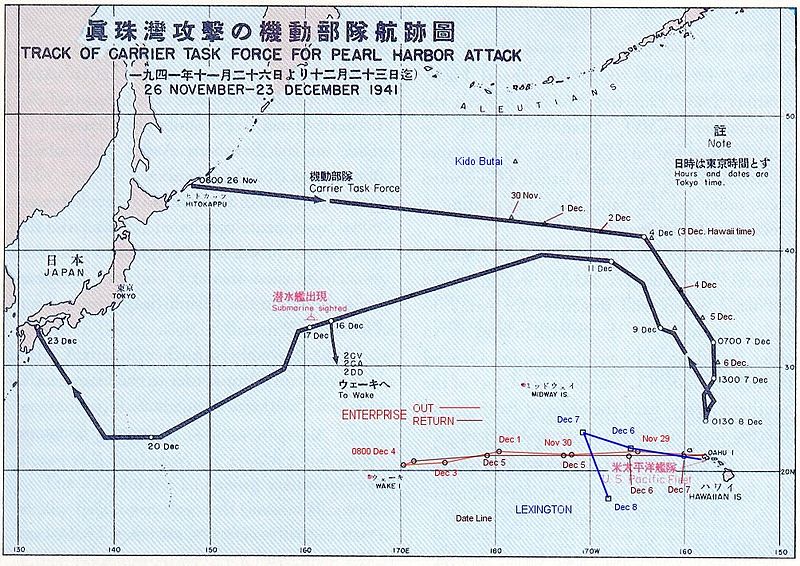
English: The route of the Japanese flotilla (Kido Butai), with the USS Enterprise (in red) and the USS Lexington (in blue) to the South.
Public Domain chart from "Reports of General MacArthur, prepared by his General Staff." This book was printed by GPO. The chart shows the routes of the Japanese attack force to and from Pearl Harbor. I have added the routes of the two American carriers.
This work is in the public domain in the United States because it is a work prepared by an officer or employee of the United States Government as part of that person’s official duties under the terms of Title 17, Chapter 1, Section 105 of the US Code.
Note: This only applies to original works of the Federal Government and not to the work of any individual U.S. state, territory, commonwealth, county, municipality, or any other subdivision. This template also does not apply to postage stamp designs published by the United States Postal Service since 1978. (See § 313.6(C)(1) of Compendium of U.S. Copyright Office Practices). It also does not apply to certain US coins; see The US Mint Terms of Use.
|
 | |
| Fail ini telah dikenal pasti sebagai bebas daripada sekatan-sekatan yang dikenali mengikut undang-undang hak cipta, termasuk semua hak berkaitan dan berjiran. | ||
(got from en.wikipedia)
Sejarah fail
Klik pada tarikh/waktu untuk melihat rupa fail tersebut pada waktu itu.
| Tarikh/Waktu | Gambar kenit | Ukuran | Pengguna | Komen | |
|---|---|---|---|---|---|
| semasa | 15:20, 18 Oktober 2005 | | 1,004 × 710 (213 KB) | Unf~commonswiki | Public Domain chart from "Reports of General MacArthur, prepared by his General Staff." This book was printed by GPO. The chart shows the routes of the Japanese attack force to and from Pearl Harbor. I have added the routes of the two American carriers. |
Penggunaan fail
Laman berikut menggunakan fail ini:
Penggunaan fail sejagat
Fail ini digunakan oleh wiki-wiki lain yang berikut:
- Penggunaan di af.wikipedia.org
- Penggunaan di ar.wikipedia.org
- Penggunaan di az.wikipedia.org
- Penggunaan di bg.wikipedia.org
- Penggunaan di ca.wikipedia.org
- Penggunaan di cs.wikipedia.org
- Penggunaan di da.wikipedia.org
- Penggunaan di en.wikipedia.org
- Penggunaan di et.wikipedia.org
- Penggunaan di fr.wikipedia.org
- Penggunaan di fy.wikipedia.org
- Penggunaan di he.wikipedia.org
- Penggunaan di hu.wikipedia.org
- Penggunaan di id.wikipedia.org
- Penggunaan di it.wikipedia.org
- Penggunaan di ja.wikipedia.org
- Penggunaan di nl.wikipedia.org
- Penggunaan di no.wikipedia.org
- Penggunaan di pl.wikipedia.org
- Penggunaan di pt.wikipedia.org
- Penggunaan di ru.wikipedia.org
- Penggunaan di sk.wikipedia.org
- Penggunaan di tr.wikipedia.org
- Penggunaan di ur.wikipedia.org
- Penggunaan di vi.wikipedia.org
- Penggunaan di zh.wikipedia.org