Fail:Three Mile Island (color).jpg
Saiz pralihat ini: 625 × 600 piksel. Leraian-leraian lain: 250 × 240 piksel | 500 × 480 piksel | 800 × 768 piksel | 1,067 × 1,024 piksel | 2,134 × 2,048 piksel | 2,592 × 2,488 piksel.
Fail asli (2,592 × 2,488 piksel, saiz fail: 2.62 MB, jenis MIME: image/jpeg)
Ringkasan
| Keterangan |
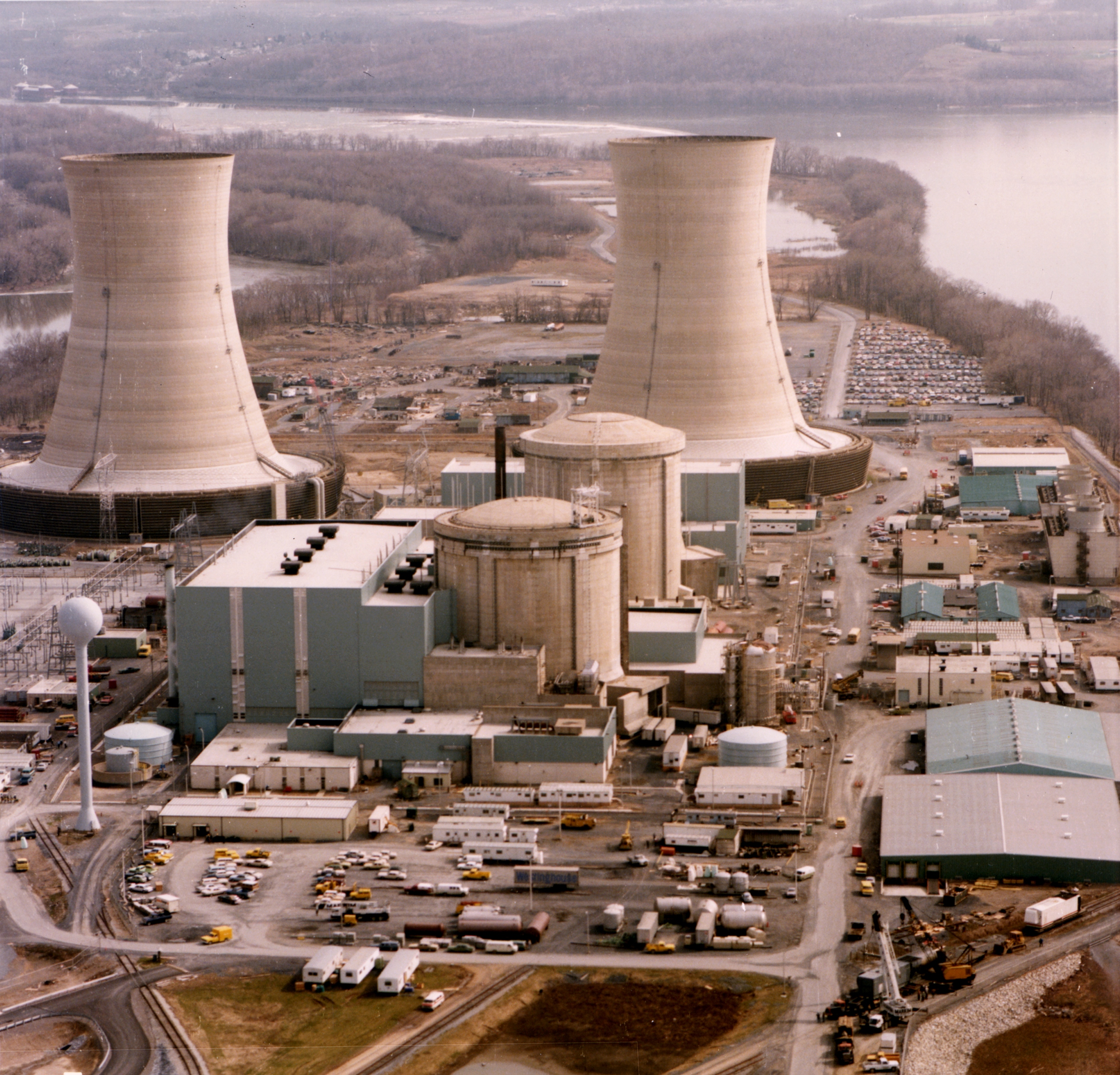
English: Color photograph of the Three Mile Island nuclear generating station, which suffered a partial meltdown in 1979. The reactors are in the smaller domes with rounded tops (the large smokestacks are just cooling towers).
Français : Photographie en couleurs de la centrale nucléaire de Three Mile Island, aux états-Unis, qui a subi une fusion partielle d'un de ses réacteurs, en 1979. Les réacteurs sont dans les dômes en béton. Les grandes cheminées ne sont que de tours de refroidissement. |
| Tarikh | |
| Sumber | http://ma.mbe.doe.gov/me70/history/photos.htm |
| Pengarang | United States Department of Energy |
| Kebenaran (Penggunaan semula fail ini) |
Identified on DOE page as "DOE photo", i.e. not copyrighted. |
| Versi lain |
|
-2.jpg)
.jpg)
| Lokasi kamera | | Paparkan imej ini dan imej berdekatan yang lain di: OpenStreetMap |
|---|
.jpg¶ms=040.156606_N_-076.725812_E_globe:Earth_type:camera_region:US_heading:180.00&language=ms)

|
Imej ini telah dinilai berdasarkan kriteria imej bernilai dan ia dianggap sebagai imej paling bernilai di Commons dalam ruang lingkup: Three Mile Island Nuclear Generating Station. Anda boleh melihat pencalonannya di Commons:Valued image candidates/Three Mile Island (color).jpg. |
.jpg)
Perlesenan
| This image is a work of a United States Department of Energy (or predecessor organization) employee, taken or made as part of that person's official duties. As a work of the U.S. federal government, the image is in the public domain.
Please note that national laboratories operate under varying licences and some are not free. Check the site policies of any national lab before crediting it with this tag.
|

|
Sejarah fail
Klik pada tarikh/waktu untuk melihat rupa fail tersebut pada waktu itu.
| Tarikh/Waktu | Gambar kenit | Ukuran | Pengguna | Komen | |
|---|---|---|---|---|---|
| semasa | 09:36, 4 November 2011 | | 2,592 × 2,488 (2.62 MB) | Yann | higher resolution, better colors |
| 15:24, 21 Oktober 2009 |  | 2,592 × 2,500 (2.59 MB) | Pieter Kuiper | Higher resolution from http://narademo.umiacs.umd.edu/cgi-bin/isadg/viewobject.pl?object=77214 | |
| 12:48, 1 Ogos 2005 |  | 678 × 532 (420 KB) | Fastfission~commonswiki | Color photograph of the Three Mile Island nuclear generating station. Source: http://ma.mbe.doe.gov/me70/history/photos.htm Copyright status: Identified on DOE page as "DOE photo", i.e. not copyrighted. {{PD-USGov-DOE}} |
Penggunaan fail
3 buah laman berikut menggunakan fail ini:
Penggunaan fail sejagat
Fail ini digunakan oleh wiki-wiki lain yang berikut:
- Penggunaan di cs.wikipedia.org
- Penggunaan di de.wikipedia.org
- Penggunaan di en.wikibooks.org
- Penggunaan di es.wikipedia.org
- Penggunaan di it.wikipedia.org
- Penggunaan di ja.wikipedia.org
- Penggunaan di ko.wikipedia.org
- Penggunaan di pt.wikipedia.org
- Penggunaan di sk.wikipedia.org
- Penggunaan di sl.wikipedia.org
- Penggunaan di th.wikipedia.org
- Penggunaan di tr.wikipedia.org
- Penggunaan di zh-classical.wikipedia.org
- Penggunaan di zh.wikipedia.org
.jpg)