Fail:1902-pelee-map.jpg

Fail asli (804 × 1,200 piksel, saiz fail: 870 KB, jenis MIME: image/jpeg)
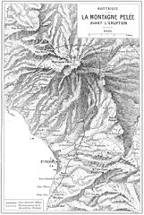
Alfred LaCroix. La Montagne Pelee et ses Eruptions. Paris, Masson et Cie, 1904. A relief map of Mount Pelee (Montagne Pelee in French) showing the area affected by the eruptions of 8 May and 30 August, 1902. The map is from page 223.
|
Karya ini berada dalam domain awam di negara-negara dengan tempoh hak cipta hayat pencipta ditambah 70 tahun atau kurang.
| |
| Fail ini telah dikenal pasti sebagai bebas daripada sekatan-sekatan yang dikenali mengikut undang-undang hak cipta, termasuk semua hak berkaitan dan berjiran. | |
Sejarah fail
Klik pada tarikh/waktu untuk melihat rupa fail tersebut pada waktu itu.
| Tarikh/Waktu | Gambar kenit | Ukuran | Pengguna | Komen | |
|---|---|---|---|---|---|
| semasa | 04:41, 14 Oktober 2005 | | 804 × 1,200 (870 KB) | Jerry7171 | Alfred LaCroix. La Montagne Pelee et ses Eruptions. Paris, Masson et Cie, 1904. A relief map of Mount Pelee (Montagne Pelee in French) showing the area affected by the eruptions of 8 May and 3 August, 1902. The map is from page 223. |
Penggunaan fail
Laman berikut menggunakan fail ini:
Penggunaan fail sejagat
Fail ini digunakan oleh wiki-wiki lain yang berikut:
- Penggunaan di ast.wikipedia.org
- Penggunaan di ca.wikipedia.org
- Penggunaan di cs.wikipedia.org
- Penggunaan di en.wikipedia.org
- Penggunaan di es.wikipedia.org
- Penggunaan di fi.wikipedia.org
- Penggunaan di fr.wikipedia.org
- Penggunaan di gl.wikipedia.org
- Penggunaan di ja.wikipedia.org
- Penggunaan di lv.wikipedia.org
- Penggunaan di pl.wikipedia.org
- Penggunaan di pt.wikipedia.org
- Penggunaan di vi.wikipedia.org
- Penggunaan di zh.wikipedia.org