Fail:All-sky map of measured skyglow brightness.png

Saiz pralihat ini: 800 × 296 piksel. Leraian-leraian lain: 320 × 118 piksel | 640 × 237 piksel | 1,557 × 576 piksel.
Fail asli (1,557 × 576 piksel, saiz fail: 737 KB, jenis MIME: image/png)
Ringkasan
| Keterangan |
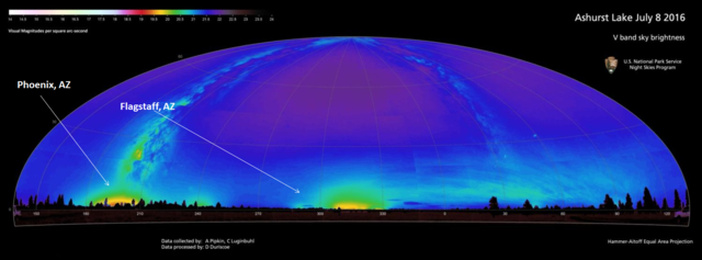
English: A calibrated all-sky map of the skyglow from near Ashurst Lake, AZ, USA |
| Tarikh | Sept 2016 |
| Sumber | My own records (I am a co-author of the work) |
| Pengarang | Pipkin, A., Duriscoe, D. & Luginbuhl, C. |
- Other information
Credit authors Pipkin, A., Duriscoe, D. and Luginbuhl, C. and U.S. National Park Service if using this image.
Perlesenan
| This image or media file contains material based on a work of a National Park Service employee, created as part of that person's official duties. As a work of the U.S. federal government, such work is in the public domain in the United States. See the NPS website and NPS copyright policy for more information. |
Sejarah fail
Klik pada tarikh/waktu untuk melihat rupa fail tersebut pada waktu itu.
| Tarikh/Waktu | Gambar kenit | Ukuran | Pengguna | Komen | |
|---|---|---|---|---|---|
| semasa | 21:02, 26 Februari 2017 | 1,557 × 576 (737 KB) | Cluginbuhl | Uploading a public-domain item using File Upload Wizard |
Penggunaan fail
Laman berikut menggunakan fail ini:
Penggunaan fail sejagat
Fail ini digunakan oleh wiki-wiki lain yang berikut:
- Penggunaan di en.wikipedia.org