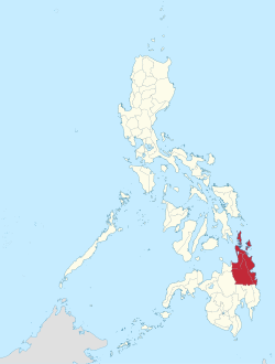
Caraga
Caraga ialah sebuah daerah di Filipina. Daerah ini mempunyai jumlah penduduk seramai 2,804,788. Ibu kotanya ialah Butuan.
Ia terdiri daripada wilayah:
Caraga | |
|---|---|
 Peta Filipina dengan Caraga dipaparkan | |
 | |
| Koordinat: 8°55′N 125°30′E / 8.92°N 125.5°EKoordinat: 8°55′N 125°30′E / 8.92°N 125.5°E | |
| Negara | Filipina |
| Barangay | 1311 |
| Pentadbiran | |
| • Pengundi | 1,760,582 (9 Mei 2019) |
| Keluasan | |
| • Jumlah | 21,478.35 km2 (8,292.84 batu persegi) |
| Penduduk (1 Mei 2020) [2] | |
| • Jumlah | 2,804,788 |
| • Kepadatan | 130/km2 (340/batu persegi) |
| • Bilangan rumah | 565,495 |
| Zon waktu | UTC+8 |
| PSGC | 160000000 |
| Bahasa peribumi | Bahasa Mamanwa Mandaya Agusan Manobo |
Demografi
sunting| Tahun | Pend. | ±% setiap tahun |
|---|---|---|
| 1903 | 115,112 | — |
| 1918 | 166,904 | +2.51% |
| 1939 | 324,918 | +3.22% |
| 1948 | 391,400 | +2.09% |
| 1960 | 631,007 | +4.06% |
| 1970 | 950,129 | +4.17% |
| 1975 | 1,114,336 | +3.25% |
| 1980 | 1,371,512 | +4.24% |
| 1990 | 1,764,297 | +2.55% |
| 1995 | 1,942,687 | +1.82% |
| 2000 | 2,095,367 | +1.64% |
| 2007 | 2,293,346 | +1.25% |
| 2010 | 2,429,224 | +2.12% |
| 2015 | 2,596,709 | +1.28% |
| 2020 | 2,804,788 | +1.53% |
| Ref: Lembaga Perangkaan Filipina [4] [5] [6] | ||
Ekonomi
sunting| Kadar kemiskinan | |
| Ref: Lembaga Perangkaan Filipina[7][8][9][10][11][12][13][14][15] | |
Rujukan
sunting- ^ "Province:". PSGC Interactive. Bandar Quezon, Filipina: Lembaga Perangkaan Filipina. Dicapai pada 12 November 2016.
- ^ Census of Population (2020). "Caraga". Total Population by Province, City, Municipality and Barangay. PSA. Dicapai pada 8 Julai 2021.
- ^ "2021 Full Year Official Poverty Statistics of the Philippines" (PDF). 15 Ogos 2022. Dicapai pada 28 April 2024.
- ^ Census of Population (2015). "Caraga". Total Population by Province, City, Municipality and Barangay. PSA. Dicapai pada 20 Jun 2016.
- ^ Census of Population and Housing (2010). "Caraga". Total Population by Province, City, Municipality and Barangay. NSO. Dicapai pada 29 Jun 2016.
- ^ Censuses of Population (1903–2007). "Caraga". Table 1. Population Enumerated in Various Censuses by Province/Highly Urbanized City: 1903 to 2007. NSO.
- ^ "Kadar kemiskinan:". Lembaga Perangkaan Filipina. Dicapai pada 28 Disember 2020.
- ^ "Estimation of Local Poverty in the Philippines" (PDF). 29 November 2005.
- ^ "2009 Official Poverty Statistics of the Philippines" (PDF). 8 Februari 2011.
- ^ "Annual Per Capita Poverty Threshold, Poverty Incidence and Magnitude of Poor Population, by Region and Province: 1991, 2006, 2009, 2012 and 2015". 27 Ogos 2016.
- ^ "Annual Per Capita Poverty Threshold, Poverty Incidence and Magnitude of Poor Population, by Region and Province: 1991, 2006, 2009, 2012 and 2015". 27 Ogos 2016.
- ^ "Annual Per Capita Poverty Threshold, Poverty Incidence and Magnitude of Poor Population, by Region and Province: 1991, 2006, 2009, 2012 and 2015". 27 Ogos 2016.
- ^ "Annual Per Capita Poverty Threshold, Poverty Incidence and Magnitude of Poor Population, by Region and Province: 1991, 2006, 2009, 2012 and 2015". 27 Ogos 2016.
- ^ "Updated Annual Per Capita Poverty Threshold, Poverty Incidence and Magnitude of Poor Population with Measures of Precision, by Region and Province: 2015 and 2018". 4 Jun 2020.
- ^ "2021 Full Year Official Poverty Statistics of the Philippines" (PDF). 15 Ogos 2022. Dicapai pada 28 April 2024.
